

By Gary McKechnie
While Florida is designed for one long road trip, in only one of its 67 counties can you explore a forest steeped in mystery, travel along what I’d argue is the state’s best stretch of coastline, and cross a bridge back in time to the 1960s.
Welcome to Franklin County.
After exploring dozens and dozens of Florida’s most rural counties, certain memories stand out. Like the forest road that led to a pristine river where the breeze hummed through the longleaf pines, the sleepy harbor where a fleet of weathered shrimp boats showed scars from long days at sea, the distant barrier islands that set up the Allies for success on D-Day.
Each of these memories was minted in Franklin County. From the beaches of St. George Island to the depths of Tate’s Hell State Forest, from the beaches of Carrabelle to the fishing village that’s become an artists’ colony, it’s all right here. Incredibly, with most of the county covered by marshes, woodlands, rivers, and bays, the areas you can actually explore by car are limited but, oh, so impressive. The lack of habitable land also explains why this is Florida’s third-least populated county.
Apalachicola
Most travelers launch their tour in the county seat of Apalachicola, a place I enjoy visiting again and again. Aside from the name, which locals say is Hitchiti for "friendly people over there,” what tickles me about Apalachicola is that it constantly reinvents itself. In the mid-1800s it was a bustling port town shipping cotton at the southern terminus of the Apalachicola River. When cotton failed they switched to harvesting sponges and after depleting that crop they started on oysters. Efforts are now underway to restore the habitat for the bivalves.
Here in “Apalach,” the most recent cash crop over the past few decades has become tourism, with enough attractions to keep visitors entertained for a hectic day or, preferably, a long, leisurely weekend.
It’s easy to fall for the town. Although new buildings (mostly lodging) are rising to accommodate visitors, the odd thing is that the town’s historic Cracker cottages, Queen Anne manors, and red brick buildings are so real they look fake. Trust me, it’s authentic – the historic business district and its brewpubs, the collection of unique shops selling original artwork and photographs, the boutiques with the latest fashions, the parks, the waterfront, the gothic churches and inviting bed and breakfasts.
What makes Apalach even more appealing is that the core of town is walkable while most sights worth seeing are just a short drive away.
So after you ramble around the village, get lost in the Historic District where some residents have converted their homes into art galleries and spas.
For a nice photo op, start early and head to the marina where shrimp boats that look as broken and beaten as an 0-30 boxer are moored as they await their next run. A few blocks away, Veterans Memorial Park includes a partial casting of the Three Soldiers sculpture found at the Vietnam Veterans Memorial in Washington D.C. Standing here in the early morning quiet can be an eerie and unforgettable privilege. In the background is the Orman House Historic State Park where a magnificent 1838 antebellum home is complemented by the Chapman botanical gardens, named for Dr. Alvin Champman, a botanist and author who gained international fame in the mid-1800s for his study of Southern plants.
Closer to town is a second state park that pays tribute to one of Florida’s most important people. At the John Gorrie Museum State Park you’ll learn how this local physician created a process to cool victims of yellow fever, the methods of which were later applied to ice-making machines and patents used in air conditioning. Without knowing it, John Gorrie was the man who made Florida habitable.
One last thing about Apalachicola. On any given day you’ll see three different towns. Following the slow awakening of this remote coastal community comes the hum of retail activity. After the sun sets, the town slips into a kind of movie set nightlife, with locals and visitors gathering in the village to dine at a variety of restaurants and frequent wine bars and brewpubs like the Oyster City Brewing Company and Owl Café.

Franklin County water view
- Gary McKechnie for VISIT FLORIDA
The Bridge
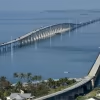
At the end of Market Street is the highly recommended Gibson Inn, the focal point of town when arriving from the east. From here, the bridge crosses the water where the Apalachicola River meets Apalachicola Bay and continues its long eight-mile run to the town of Eastpoint. When you reach the mainland again, take a right onto Island Drive which leads to an even longer span that takes you out to sea.
With apologies to St. Pete’s Sunshine Skyway, the Bryant Grady Patton Bridge looks like a sleek, slender ribbon tied to a most beautiful barrier island. If you’re traveling with fishing gear, when you reach the island, look beside the bridge for a parking area/boat launch/fishing pier.

St. George Island Lighthouse
- Gary McKechnie for VISIT FLORIDA
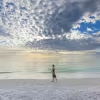
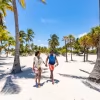
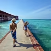
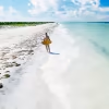
Give St. George Island as much time as you can. Where the road reaches the Gulf, the nostalgic scene is reminiscent of the days when Florida’s beach towns were uncluttered by chain stores and towering resorts. Before you, another sign of Florida’s past stands out like a beacon: The St. George Lighthouse. Once located at the west end of the island, after erosion caused it to fall into the Gulf in 2005, it was rebuilt here in 2008. You can climb to the top for a panoramic view of the 22-mile island, the bay, the mainland, and the Gulf of Mexico, and visit a museum and gift shop within a replicated Keeper’s House.
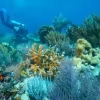
Here and for miles in either direction, public beaches and access points lead to a day on the water, although several miles of the western tip of the island are locked behind the domain of a gated community. Conversely, if you drive four miles east you’ll reach St. George Island State Park. The park preserves nine miles of undisturbed shoreline that creates the longest shoreline of any state park in Florida along with some of the state’s highest-ranked beaches. With its open waters, oak and pine forests, bald eagles and ospreys, salt marshes and sandy coves, this park is perfect for swimming, canoeing, boating, hiking, camping, fishing, shelling, birding… or all of the above.
On The Road Again
The return trip across the bridge to Eastpoint begins what some would consider the best part of a Franklin County excursion: A road trip.
Depending on your mood, there are two distinctly different and equally wonderful choices with the first leg leading into the forest and the second along the coast. Here’s a hint: Do them both because whether it’s early morning, mid-afternoon, or late in the day, there’s hardly anything more pleasing than exploring the Big Bend National Scenic Byway, part of which includes C.R. 65 and U.S. 98 in Franklin County.
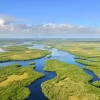
A few miles east of Eastpoint you’ll find the Franklin County Welcome Center, which is a great source for maps, guidebooks, brochures and information. A short distance beyond that, C.R. 65 leads to the north and ushers into the ominously-named Tate’s Hell State Forest.
The legend is that in 1875, Cebe Tate got lost in the woods and swamps and when the delirious hunter emerged, he told everyone he had just been through hell. A ranger station about seven miles north on C.R. 65 includes information, maps, and markers for campsites and hiking trails. Much of the forest is intersected by tributaries of the Apalachicola Rive while maps list locations for boat ramps at places like Whiskey Gorge Creek, Doyle Creek, Graham Creek with roadside signs pointing to the same. What I found to be one of the most beautiful places in Florida was Cash Creek.
A hard-packed road entered the pine forest and led to a launch area about a half-mile in. This was natural Florida at its best. The marsh was quiet and still and the reeds in the water created a jigsaw of paths perfectly designed for canoes and kayaks – yet none were there. I longed for a kayak, knowing I could paddle to the river and then the bay and then to the Gulf and then to all points around the world. Lacking a boat, I savored the quiet forest where the silence was broken only by the steady hum of wind whispering through the pines.
This only scratches the surface. With Tate’s Hell State Forest merging with the Apalachicola National Forest, the two encompass most of Franklin County, making this area perfect for sportsmen. On a map, dots indicate communities like Creeks, Beverly, and Bucks Siding but nearly nothing is there. Along C.R. 65, only Sumatra in neighboring Liberty County is a town of any size.
Back on the coast awaits what I believe is the Florida’s most beautiful stretch of highway. U.S. 98 east to Carrabelle is a dream, like the Pacific Coast Highway but better since it’s right on the water. Along the way, the roads twists and turns and sweeps along the coast, with each curve pulling you forward into stunning views of the mudflats exposed in the shallows and the profile of islands far out across the water. Often, towering pines create a tunnel of trees that let you zip through a canopy road. About 12 miles from Eastpoint, look to your left for the Crooked River Lighthouse Park. In addition to being a nice photo op, the 103-foot lighthouse is joined by a small museum within the Keeper’s House that includes original items such as meteorological instruments and pages from the keeper’s watch book.

Sunset in Franklin County
- Gary McKechnie for VISIT FLORIDA
Carrabelle
The road continues to Carrabelle where you’re welcomed by a bit of history. Not just the beach park picnic shelters with their retro-hip ‘60s Space Age design, but by two historic markers revealing this area played a crucial role in the outcome of World War II. It was here at Camp Gordon Johnston that troops trained for the D-Day invasion, using Carrabelle Beach and Dog Island (which you can see across the bay) as landing sites. At the same time, Franklin County’s woods were used for jungle training.
It’s exciting to visualize the young men preparing here for the real thing, a historic fact that makes the small war memorial in the heart of town perfectly placed, as is the Camp Gordon Johnston Museum beside the city complex a short drive away.
Something else Carrabelle is well suited for is fishing. You’ll notice that when you cross the Carrabelle River into “The Gateway to the Gulf” where the town sign with an oversize lure reads “Carrabelle: Get Hooked.” A row of marinas sweeps along a bend in the river, and signs for deep-sea charters invite you to test your luck.
When you turn onto Marine Street, the Riverwalk accents the waterfront with public art, a waterfront pavilion, and a station where you can clean your catch. Nearby, a ferry landing awaits passengers heading to far-off Dog Island. More remote than Dog Island is the eastern edge of Franklin County.
U.S. 98 continues for about 25 more miles, with relatively sparse development along the way. At some point you’ll arrive at Alligator Point, a narrow beach peninsula bordered by the Gulf and an estuary known as Alligator Harbor. At the peninsula’s eastern edge, the Bald Point State Park protects 5,000 acres of wilderness, which makes it a favorite landing spot for migrating Monarch butterflies as well as birds, which earns it a spot on the Great Florida Birding Trail.
It may be remote, it may be undeveloped, but from history to nature to recreation to hospitality and scenic beauty, Franklin County is the best of all worlds.
What Else?
The Franklin County Tourist Development Council shares in-depth information about the entire range of activities and services travelers seek, from golfing, fishing, birding, and restaurants to shopping, weddings, adventures and parks. To dig deeper, visit SaltyFlorida.com.


Apalachicola on the River: History and Small Town Appeal
- 4 minute read
With a population under 3,000, Apalachicola has preserved its history and small-town appeal. Come here for seafood, charming inns and a growing arts...

5 Things for Families to Do on St. George Island
- 2 minute read
By Carrie McLaren During a recent visit to Apalachicola, we took a drive over to see St. George Island and discovered a natural, beautiful beachfront,...

Gloriously Wild: Tate's Hell State Forest & the High Bluff Hiking Trail in Carabelle, Florida
- 2 minute read
Located on the Forgotten Coast near Carrabelle in Northwest Florida, Tate's Hell State Forest covers more than 200,000 acres and boasts a...

