


Stop in the nation's oldest city, for the ocean vistas, in the nature preserves and parks and, finally, on the Isle of Eight Flags.
One of the hundreds of reasons I love living in Florida is that I can hit the road any time of the year. When I have a desire to ride a remote two-lane that blazes through a tunnel of trees, I go. If I want to scale the rolling hills in Ocala horse country, they’re waiting. Then there’s A1A, the road that favors Florida’s Atlantic Coast. This would be a short 65-mile journey between St. Augustine and Amelia Island and so, for convenience, I started at Point A.
The Ancient City
You’d think at more than 400 years old, St. Augustine would show signs of slowing down, but America’s oldest city looks like it’s just getting started.
For the best overview of the city, the sightseeing trains will pique your interest with the history and layout of St. Augustine as you note places to return. The historic district, where most visitors spend their time, is accented by dozens of beauty marks that create one of the loveliest cities in America. Stroll the promenade along the broad waters of Matanzas Bay, hear the steady hoofbeats of horse and carriage, explore sturdy Castillo de San Marcos, and peruse the shops of St. George Street, the extremely popular pedestrian mall that is lined with gift shops, art boutiques and restaurants. That evening, walk to the marina where gleaming yachts from around the world sparkle under starlight.
En Route
Between St. Augustine and Amelia Island, A1A sticks to the Atlantic Ocean for a fair share of the way. On the north end of America’s Oldest City, leap over the Vilano Causeway to reach the waterfront community of Vilano Beach then simply follow A1A north along the shoreline, either resisting or giving in to the temptation to stop along the way and enjoy the solitude of this quiet shoreline.
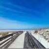
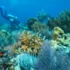
Mile after mile, you can ride or drive and enjoy the sight that draws people from around the world to Florida, where the Atlantic Ocean meets the sands of the Sunshine State. Approximately seven miles north of Vilano Beach, Guana Tolomato Matanzas National Estuarine Research Reserve is a 73,000-acre sanctuary for hiking, biking, fishing, kayaking, canoeing and birdwatching among the hammock, scrub and flatwoods, with convenient parking areas on the west side of A1A providing access to the ocean across the street. For many miles opposite the reserve, you’ll find beach houses, some ostentatiously grand and hidden behind walls of foliage, others small and rustic and open.
Too soon, A1A leads away from the ocean, becoming a wide commercial avenue through planned communities and business districts. If you have time and curiosity, at the intersection of A1A and Mickler Road turn right to reach Ponte Vedra Boulevard, followed by Duval Drive and Ocean Drive, which do their best to keep you close to the shore although rows of homes and hedges may limit your view. If you choose to follow these roads less traveled, you'll be able to stick close to the ocean past Jacksonville and Neptune and Atlantic beaches (see the Jacksonville Beach Pier) while staying within easy reach of A1A.
Either way you go, there’s a payoff ahead. When you arrive in Mayport, a sign tells you the village was established in May of ’62.
That’s 1562.
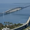
In addition to longevity, Mayport’s known for a most interesting feature: the St. Johns River Ferry that carries pedestrians, motorcycles, and cars and trucks on a five-minute journey across the waters. On the opposite bank, turn right and Amelia Island is only 10 miles away and the island’s only city, Fernandina Beach, 17 miles distant. With wide swaths of open marshland spreading east and west, the surrounding scenery places you in the middle of a Florida Highwaymen painting, offering a sense of the state’s magnificence and a gathering place for migratory fowl that follow the Great Florida Birding and Wildlife Trail. Through Little Talbot Island State Park, one of the few remaining undeveloped barrier islands in northeast Florida, and Big Talbot Island State Park, A1A consistently delivers incredible views.
Soon, manicured landscaping lets you know that elaborate resorts are somewhere along the waterfront, but as you cross the bridge onto Amelia Island the destination’s true character is seen in produce stands and canopy roads that open to a row of homes fronting the broad ocean. It is all part of a most extraordinary place.
The Isle of Eight Flags
You could search from Key West to Anchorage, but you’ll never find a place like Amelia Island, which, in its history, has been ruled under eight flags. In its 450 years, Amelia Island was controlled by the French (1562-1565), the Spanish (1565-1763), the English (1763-1783), the Spanish again (1783-1821) with interruptions by the "Patriots" (1812), Green Cross of Florida (1817), Mexican Rebels (1817), United States (1821) and the Confederacy (1861).
Things have calmed down since, and if you’re not relaxing on the waterfront, you’ll likely be exploring Centre Street, which is the island’s most active commercial district with antique shops, art galleries, bookstores and gift shops. Downtown, the old train depot is now the community visitor center and the historic Palace Saloon, which opened its doors in 1903, is still welcoming visitors despite a fierce fire in 1999.
Take time to explore. A few miles east of the shopping village, turn left on 14th Street and you’ll find Bosque Bello, a cemetery established by Spanish settlers in 1798. A short distance beyond, Old Town was platted in 1811 as the island’s original town. Now more than 200 years old, a small number of homes are still here, perched on a small rise above the Amelia River.
It may only be a short distance between St. Augustine and Fernandina Beach, but when you add in 450 years of history, 65 miles of scenic Florida and the charm of A1A and other oceanfront roads, this is a journey of historic proportions.


